QSR Geofencing Platforms: 2026 Strategic Advertising Guide
Top Geofencing Advertising Platforms for QSR Franchises: 2026 Strategic Analysis

The 2026 QSR Landscape and the Strategic Imperative of Geofencing
The Quick Service Restaurant (QSR) industry has undergone a profound architectural shift, transitioning from fragmented digital touchpoints to unified commerce ecosystems. This evolution is driven by the confluence of hyper-automation, predictive analytics, and precision location intelligence. As the market navigates the economic realities of 2026—characterized by sustained inflation, chronic labor shortages, and unprecedented customer pressure for frictionless convenience—geolocation technology has evolved far beyond the rudimentary proximity marketing tactics of the previous decade. It now serves as the central nervous system for both customer acquisition and operational fulfillment, effectively bridging the chasm between digital consumer intent and physical restaurant execution. Current market analytics indicate that businesses effectively integrating geographical data into their strategic marketing and operational frameworks outperform their competitors by an average of 41%.
For multi-unit QSR franchises, the application of geofencing technology addresses two distinct but inextricably linked imperatives. First, it drives localized, high-intent foot traffic through highly targeted programmatic digital advertising. Second, it optimizes back-of-house kitchen operations through real-time arrival detection for curbside, drive-thru, and mobile order pick-up workflows. The maturation of this technology represents a pivot from passive data collection to active operational triggering. Major QSR chains and aggressive franchisees—including global entities like McDonald’s, Starbucks, Dunkin’, and Panera Bread—have fundamentally embraced geofencing to streamline the preparation of digital orders, combat labor constraints, and provide hyper-contextualized mobile experiences.
The franchising model inherently operates on a delicate dichotomy: the absolute necessity for centralized corporate brand control juxtaposed with the mandatory demand for decentralized, localized market execution. Franchise brands succeed primarily by integrating themselves into the contextual daily behaviors of the specific neighborhoods and communities they serve. This requires reaching consumers not merely within a rigid, arbitrary geographic radius, but at the exact moments of highest commercial intent—whether they are dwelling in a competitor’s parking lot, commuting past a designated retail zone during a specific daypart, or attending a local weekend sporting event. Historically, franchise marketing suffered from a centralized “one-size-fits-all” approach, resulting in generic messaging that completely failed to account for localized demand, micro-economic factors, or specific competitive density. The failure to understand and adapt to the core local customer base has historically proven disastrous; the sharp decline of legacy chains like Quiznos is often cited as a cautionary tale of strategic marketing misalignment and the failure to adapt messaging to local consumer realities.
Modern geofencing platforms resolve this operational friction by facilitating centralized corporate oversight while simultaneously granting franchisees the autonomy to execute localized campaigns. Advanced ad-tech platforms now offer sophisticated multi-location dashboards that allow franchisors to enforce brand standards, measure network-wide analytics, and allocate dedicated budgets, while regional franchisees can leverage customized creatives and precise location-level targeting. By tailoring advertising messages to local civic events, real-time weather conditions, and direct competitor proximity, franchises can finally achieve massive national scale with surgical hyperlocal precision.
The Architecture of Spatial Intelligence: Mapping Mechanisms

Polygons, Plat Lines, and Proprietary Blueprints
Modern geofencing vendors utilize advanced, multi-layered boundary definitions to eliminate fraudulent, inaccurate, or irrelevant data signals, ensuring that marketing budgets are not wasted on consumers who are merely adjacent to a target zone without true visitation intent.
Proprietary mapping technologies represent a major competitive moat for top-tier platforms. GroundTruth, for instance, utilizes a technology termed “Blueprints.” This system accurately draws virtual boundaries across three distinct physical layers: the interior of the store, the immediate parking lot, and the broader surrounding retail area. This tri-layered approach is critical for QSRs, as it allows marketers to distinguish between a consumer sitting in the dining room versus one parked in a curbside slot, preventing advertising waste on consumers merely passing by a location on an adjacent highway or walking through a connected shopping mall without intent. GroundTruth maintains a repository of nearly six million mapped Blueprints globally, processing over 30 billion physical visits annually.
Conversely, platforms rooted in programmatic Demand-Side Platform (DSP) architectures, such as Simpli.fi, rely heavily on addressable plat line data. Plat lines map the exact, legally defined physical property boundaries of a location based on municipal tax and real estate records. This allows for exact household-level targeting without relying on less accurate IP address targeting. By matching physical addresses to precise target zones, Simpli.fi can serve highly relevant ads across mobile devices, desktop computers, and Connected TV (CTV) screens to the specific inhabitants of a verified household.
For platforms specializing in operational triggers and in-app developer tools, such as Radar and Bluedot, the focus is on optimizing Software Development Kits (SDKs) to achieve microscopic location accuracy. These developer-first platforms have engineered their SDKs to achieve location accuracy down to a 5-to-10-meter radius. This granular, sub-meter precision allows a QSR’s native mobile application to instantly differentiate between a customer entering a high-speed drive-thru lane versus a customer pulling into a designated curbside pick-up spot, triggering entirely different operational workflows in the kitchen. Furthermore, these platforms support overlapping, complex polygons and observe real-time entry and exit events with milliseconds of latency, completely operating on the device rather than relying on slower server-side processing.
The Role of Mobile Ad IDs (MAIDs) and Data Privacy Compliance
As global regulatory scrutiny intensifies and the digital advertising ecosystem prepares for the final depreciation of third-party cookies, the location marketing industry has aggressively pivoted toward privacy-compliant, consented first-party data. Transparent opt-in consent mechanisms and the ethical utilization of Mobile Ad IDs (MAIDs) are now foundational to any geofencing strategy.
Location data providers and QSR brands must navigate an increasingly complex web of local and state privacy legislation. For example, regulatory environments like those overseen by the California Attorney General, alongside specific legislation such as AB 1355, require strict opt-in consent for any location collection, sometimes impacting data collection within multi-mile radii. Consequently, first-party, consented data is viewed as the only sustainable path forward. When executed responsibly, data collection transforms into a mutually beneficial exchange of value; brands offer highly relevant content, personalized experiences, and meaningful localized offers in return for the user’s location data. A significant 71% of consumers now expect personalized, context-aware experiences from brands, making ethical location tracking a baseline consumer expectation rather than a mere marketing novelty.
Media-Centric Platforms: Driving Acquisition and Foot Traffic
The commercial marketplace for geofencing software is generally bifurcated into two distinct categories: Media-centric platforms focused on programmatic advertising, customer acquisition, and footfall attribution; and Developer-centric infrastructure platforms focused on operational tracking and in-app feature triggering.
For franchisees whose primary objective is market share expansion, competitive conquesting, and driving net-new foot traffic, the selection must focus heavily on the leading Demand-Side Platforms (DSPs).
GroundTruth: Verified Visitation and Hyper-Local Precision
GroundTruth operates as a formidable, hyper-targeted mobile advertising platform and location data provider, distinctly optimized for driving and measuring real-world in-store visits. Trusted by 7 of the top 10 Fortune 100 companies, GroundTruth’s ecosystem is anchored by its proprietary Blueprints mapping technology and a robust, multi-step data verification process.
GroundTruth differentiates itself through its patented Location Verification algorithm, which actively filters out fraudulent, inaccurate, or bouncing latitudinal and longitudinal signals before they can corrupt campaign data. The platform’s commitment to data integrity is evidenced by its accreditation from the Media Rating Council (MRC) for its Place, Location, and Visitation datasets, alongside third-party validation by Numerator certifying the platform as 99% accurate regarding verified visits.
For QSR franchises, the targeting architecture within GroundTruth is exceptionally versatile. Marketers can utilize On-Premise targeting to reach consumers currently inside specific stores—a highly effective tactic for conquesting competitor locations or providing the final nudge needed to convert a customer in a retail parking lot. For example, the breakfast brand BelVita utilized GroundTruth’s on-premise targeting in a complex multichannel campaign, serving ads to consumers inside designated retail areas and coffee shops, ultimately contributing over $476,000 in tracked sales at a remarkably efficient $0.22 Cost Per Visit (CPV). Furthermore, GroundTruth offers Neighborhood Targeting, which allows local owners to reach consumers in highly specific geographical boundaries that show high historical affinity for their particular restaurant category, as utilized effectively by the rapidly expanding franchise Dave’s Hot Chicken.
To cater specifically to the franchising model, GroundTruth offers the “Ads Manager,” an end-to-end self-serve platform that effectively democratizes enterprise-grade location data for individual franchise owners and local agencies. The Ads Manager removes common barriers to entry by requiring no massive Insertion Order (IO) contracts and no minimum spend limits, allowing local operators to scale budgets based purely on their specific micro-economic needs. The platform supports complex hierarchical structures, meaning an individual franchisee can log in to manage their specific ZIP codes, while a corporate marketing team maintains overarching visibility and reporting capabilities across the entire network. Beyond standard mobile display, GroundTruth supports deep omnichannel activation, allowing franchises to bridge physical-world audiences across Desktop, Connected TV (CTV), and Digital Out-of-Home (DOOH) screens, retargeting users who recently passed a specific highway billboard with a localized mobile coupon.
Simpli.fi: Programmatic Scale and Unstructured Data
Simpli.fi is a powerful, independent programmatic DSP renowned for its highly granular addressable geofencing capabilities and its unique utilization of unstructured data. It is explicitly engineered for multi-location franchise brands that require the delicate balance of national programmatic scale with intense localized relevance.
The core strength of Simpli.fi lies in its Addressable Geo-Fencing technology. By utilizing aforementioned plat line data, Simpli.fi maps exact property boundaries to target specific residential households. This allows franchisees to execute highly sophisticated demographic overlays. In a recent documented case study, a multi-location QSR operating over 60 locations in the western United States utilized Simpli.fi’s Addressable Audience Curation tool. By selecting from over 3,000 demographic variables, the agency curated a highly specific audience: households with an income greater than $70,000 located within 100 specific ZIP codes directly surrounding the restaurants. Simpli.fi automatically matched each residential address to property plat lines, serving targeted video and display ads across devices captured within those specific homes. The campaign resulted in 12,768 verified in-store visits at a highly efficient Cost Per Visit of $1.70.
Another massive deployment involved a fast-food burger chain operating over 350 locations in the Northeast and Midwest. To promote a new vegetarian menu item, the agency utilized Simpli.fi to curate a list of over 10.1 million households containing consumers aged 18-44 who exhibited behaviors indicating they were likely to visit QSR locations. The campaign leveraged both Addressable Programmatic and traditional Geo-Fencing, ultimately driving over 172,000 total restaurant visits at an astounding $0.87 Cost Per Store Visit.
Simpli.fi is also distinguished by its Variable Recency Targeting capabilities. This functionality allows advertisers to adjust programmatic bidding parameters in real-time based on exactly when a consumer last visited a competitor location or searched for a related restaurant category. This unstructured data approach captures high-intent users at the precise moment they are making dining decisions, avoiding the lag inherent in pre-packaged audience segments. Furthermore, Simpli.fi has launched advanced, incrementality-focused cross-device attribution protocols. Moving beyond basic IP matching, it utilizes a privacy-conscious identity science layer to measure how sequential exposure across CTV, mobile, and desktop touchpoints collectively drives incremental in-store foot traffic, ensuring legacy device-level attribution does not systematically undercount campaign impact.
Agility Ads: Rapid Deployment and Bulk Geofencing
For franchise marketing agencies that prioritize rapid campaign execution, deep audience scrubbing, and seamless zone creation, Agility Ads provides a highly specialized and nimble DSP platform.
The most prominent feature distinguishing Agility Ads in the franchise space is its innovative Bulk Geofencing tool. Traditional geofencing deployment requires the tedious, manual mapping of individual competitor locations or points of interest—a process that can consume hundreds of operational hours when executing a national franchise rollout. Agility Ads circumvents this bottleneck by allowing media buyers to utilize natural language query inputs. A marketer can simply input a query such as “Denver, Colorado - shopping centers” or “Austin, Texas - coffee shops”. The platform automatically searches for all relevant sites within that parameters and surfaces them on a digital map with building-level precision. The marketer can then review the results and instantly save hundreds of locations as active geofences with a single click.
Once these target zones are established, Agility Ads captures mobile device IDs based on time, location, and user behavior. Crucially, to ensure data integrity and maximize the Return on Ad Spend (ROAS), the collected audience data is subjected to a rigorous 36-hour algorithmic scrubbing process, aggressively eliminating bot traffic, fraudulent pings, and irrelevant devices before any ads are served. Agility also excels in historical event targeting, enabling “lookback” capabilities that allow marketers to build audiences based on attendance at specific events or locations up to 12 months in the past. This feature is highly lucrative for seasonal QSR promotions or for capturing audiences that previously frequented a competitor during a specific, historically relevant timeframe. Agility’s precision targeting strategies have been documented to generate massive financial impact, with one case study reporting 1,042 influenced purchases, $21 million in estimated client revenue, and an exceptional 1,110% ROAS.
Infrastructure Platforms: Orchestrating Operations and Fulfillment
Radar: The Developer-First Geolocation Standard
Used by 17 of the top 30 QSR brands in the United States—including industry titans like Panera Bread, Dairy Queen, Whataburger, and the massive Inspire Brands portfolio—Radar represents the industry standard for developer-first location infrastructure. Radar allows QSR technical teams to embed highly complex geolocation capabilities directly into their apps without building the infrastructure from scratch, processing over 100 billion API calls per year across hundreds of millions of devices with 99.99% uptime.
Radar’s open-source SDKs are engineered to push beyond the native limitations imposed by the iOS and Android operating systems. While native OS constraints typically restrict applications to a mere 20 circular geofences on iOS and 100 on Android, Radar enables the deployment of unlimited geofences, complex asymmetrical polygons, and machine-learning-based indoor geolocation. The platform is designed for rapid deployment, allowing technical teams to integrate the SDKs in a single development sprint.
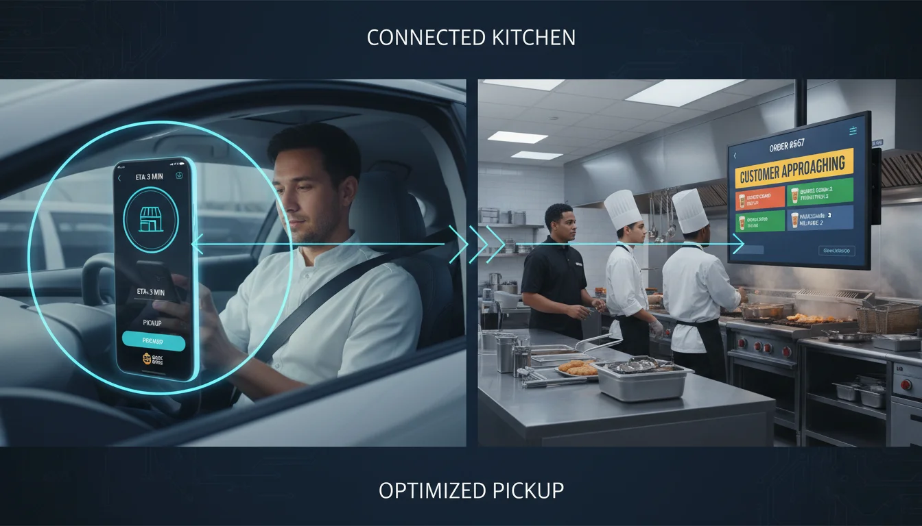
For QSR franchises, Radar’s most critical functionality is its Trip Tracking and Arrival Detection suite.
As consumer demand for order-ahead and curbside pickup continues to escalate, QSRs face intense logistical pressure to minimize customer wait times while maximizing food freshness. Radar calculates highly accurate, real-time Estimated Times of Arrival (ETAs) for customers in transit. When a customer crosses a predefined “approaching” geofence threshold, the system automatically fires an event to the restaurant’s operational software. This allows the kitchen to strategically sequence food preparation—dropping fries or assembling hot items at the exact optimal moment before the customer’s vehicle pulls into the lot, thereby improving staff efficiency and eliminating drive-thru bottlenecks. Furthermore, Radar enables contextual on-premise app experiences. The moment a user breaches the store’s property geofence, the native app can dynamically transform, unlocking specific digital loyalty cards, in-store promotions, or contactless payment interfaces to reduce friction at the counter.
Radar also aggressively competes against legacy mapping providers by offering a highly cost-effective Maps Platform API for geocoding, address autocomplete, and search routing. Pricing comparisons reveal that Radar’s geocoding costs are approximately $0.50 per 1,000 requests, compared to Google Maps’ standard rate of $5.00 per 1,000 requests. For a QSR application with massive monthly active user (MAU) volume, migrating to Radar’s maps platform can yield up to a 90% reduction in annual API overhead while actually improving routing logic.
Bluedot: Hardware-Free Precision and Frictionless Arrival
Bluedot competes directly with Radar in the realm of high-precision location SDKs, specifically targeting QSR and retail brands that require operationally critical precision for workflows like curbside pickup and drive-thru detection. Bluedot prioritizes creating frictionless customer experiences and deep integrations with enterprise CRM platforms, strictly avoiding the necessity of external hardware installations.
The core value proposition of Bluedot is its software-only ability to achieve up to 20 times the location precision of standard proximity solutions. By entirely eliminating the requirement for capital-intensive Bluetooth beacons or external Wi-Fi sniffers in drive-thru lanes or parking lots, Bluedot drastically reduces the total cost of ownership for franchise networks. Despite this intense processing power, Bluedot’s SDK is engineered for extreme energy efficiency. Background location polling loops are notoriously detrimental to mobile battery life, causing users to uninstall apps; Bluedot has optimized its algorithms to utilize less than 1/10th of the expected mobile battery drain, ensuring users keep the application installed and location permissions active.
This extreme sub-meter precision allows Bluedot to execute highly complex operational use cases. The platform can accurately distinguish the speed, heading, and exact coordinates of a vehicle, determining in real-time whether a customer has entered a high-speed drive-thru lane, parked in a designated curbside pickup slot, or walked through the front doors for a dine-in experience.
Recognizing that a significant segment of the consumer base refuses to download a dedicated native app for every restaurant chain they visit, Bluedot expanded its location technology suite to include the “Arrival Toolkit,” which features “Hello Screens” and the “Now Ready” solution. “Now Ready” is an omnichannel, completely web-based tool. When a customer places an online order, they receive an SMS or email link. Upon arriving at the restaurant, the customer simply taps the web link once. This action immediately connects to the “Hello Screens”—an intuitive, in-store dashboard mounted in the kitchen or host stand—instantly alerting staff with audio alerts and visual updates that the specific customer has arrived on-site. This provides restaurants with a quick, app-agnostic method to offer seamless curbside and in-store pickup.
Furthermore, Bluedot excels in its synergy with major marketing clouds and Customer Data Platforms (CDPs). The platform maintains native integrations with Salesforce Marketing Cloud, Braze, mParticle, and CleverTap. This allows QSR marketers to securely map physical, real-world behavioral data against digital customer profiles, powering highly personalized lifecycle engagement flows based on comprehensive 360-degree views of the customer.
The Broader Geofencing Ecosystem: Analytics and Management
While the aforementioned platforms dominate specific QSR use cases, the broader geofencing ecosystem includes several other notable players providing specialized functionalities. PlotProjects, for example, provides location-based tooling built around specific points of interest (POI) and movement-based insights. It is highly regarded for its dwell time analytics, triggering actions not just upon entry or exit, but calculating how long a user dwells within a specific zone. Foursquare remains a dominant force in raw location data and audience segmentation, boasting an unparalleled database of over 100 million points of interest globally and offering deep integration breadth with DSPs like The Trade Desk and TikTok. Additionally, enterprise platforms like AirDroid Business, Palo Alto Networks GlobalProtect, and ManageEngine provide security-focused, Mobile Device Management geofencing, essential for corporate HR compliance and tracking physical fleet assets or delivery vehicles across a franchise network.
| Platform Category | Leading Providers | Primary Franchise Application | Core Differentiator |
|---|---|---|---|
| Programmatic DSPs | Simpli.fi, Agility Ads | Customer acquisition, brand awareness, competitor conquesting | Addressable plat lines; bulk geofencing; unstructured data bidding. |
| Verified Visitation | GroundTruth | Driving guaranteed physical foot traffic; localized franchisee dashboards | CPV pricing model; MRC-accredited Blueprints; patented location verification. |
| Developer Infrastructure (SDKs) | Radar, Bluedot | Trip tracking, KDS sequencing, drive-thru/curbside operational orchestration | Hardware-free sub-meter precision; live ETAs; deep POS/Ordering integrations. |
| Location Data / POI Analytics | Foursquare, PlotProjects | Enterprise audience segmentation, dwell time analysis | Massive global POI databases; cross-platform identity graphs. |
The QSR Tech Stack: Integration Mechanics
Point of Sale (POS) and Kitchen Display Systems (KDS)
To execute seamless curbside pickup and dynamic food preparation, geolocation infrastructure must interface directly with order management systems.
A critical integration in this space is Radar’s partnership with Olo, the dominant on-demand ordering platform powering digital transactions for over 300 restaurant brands. When a digital order is placed, fired, or closed within Olo, Radar automatically initiates its trip tracking protocols. Real-time ETA milestones are continuously calculated and fired via webhooks directly into the restaurant’s operational software. This integration ensures that the digital commerce engine (Olo) and the physical location tracker (Radar) act in perfect synchronization, enabling the kitchen to optimize the exact moment of food preparation.
Similarly, POS ecosystems form the financial backbone of the franchise. Integrations with modern, cloud-centric platforms like Toast, or robust hybrid-cloud systems like NCR Aloha, allow physical location data to sync directly with transactional data. Toast’s fully cloud-based architecture allows for real-time syncing of menus, orders, and labor data across all devices. Through Toast Partner Integrations, systems like QSR Automations can connect to the POS to provide read-only KDS screens that improve kitchen workflow, lower ticket times, and support predictive bin management forecasting.
Furthermore, geofencing seamlessly facilitates localized payment solutions. Platforms like Up ‘n go integrate directly with Toast, NCR Aloha, Simphony, and Micros to generate dynamic QR codes and text payment links. When a user enters the geofenced area of a dine-in restaurant, these integrations allow customers to securely pay their checks at the table directly from their mobile devices, eliminating the need for server interaction and accelerating table turnover rates.
Loyalty, CRM, and Guest Engagement Platforms
Location data serves as the ultimate catalyst for loyalty program engagement. Understanding the “geographic potential” of a customer—defined as the highest frequency with which a customer can visit a location based on their daily commute, workplace, and home address—allows QSRs to transcend generalized promotional blasts. Sending a lunch offer to a loyalty member whose home address is near a restaurant is futile if their workplace is 20 miles away; geofencing illuminates these behavioral patterns, ensuring the right offer is sent at the right time.
The QSR loyalty landscape is dominated by platforms like PAR Punchh and Paytronix, both of which serve as the central repositories for earning rules, tier structures, and customer segmentation.
- Paytronix: Positioned as an all-in-one, multi-channel guest experience platform, Paytronix maintains a native “Geofencing Center” within its merchant portal.
This allows marketers to set specific rules, such as minimum hours between messages, maximum messages per day, and customized geofence radiuses, ensuring that push notifications surfacing on iOS and Android lock screens are used sparingly and effectively to drive incremental visits.
- PAR Punchh: Competing aggressively with Paytronix, PAR Punchh is often favored for its speed, control, and highly flexible AI-powered segmentation capabilities. Integrations between Punchh and geolocation providers allow for sophisticated marketing automation, enabling QSRs to house data across multiple sources in a single enterprise-class CRM dashboard, driving personalized journeys that scale easily across hundreds of franchise locations.
When these loyalty engines are integrated with location platforms like Bluedot or Radar, the automation becomes highly contextual. If a high-value loyalty member breaches a specific geofence during a predetermined daypart, the system autonomously triggers a hyper-relevant push notification, bridging the gap between digital loyalty points and immediate physical redemption.
The Mathematics of Footfall Attribution and Economic Models
Attribution Mechanics and Incrementality
Determining whether a digital ad actually caused a physical store visit requires sophisticated algorithmic matching. Foot traffic attribution relies on verifying opted-in mobile location signals and matching them to deterministic or probabilistic ad exposure data.
A critical component of this mathematics is the attribution window and the application of decay models. An attribution window defines the specific timeframe after ad exposure during which a store visit can legitimately “count” toward the campaign’s success. Short windows reduce statistical noise but risk missing visits driven by longer consideration phases, while long windows capture more behavior but increase the likelihood of counting completely unrelated trips. Advanced attribution systems apply sophisticated decay algorithms; logically, a store visit occurring 24 hours after ad exposure is weighted far more heavily in ROI calculations than a visit occurring 12 days later. Furthermore, these windows must be category-specific; the purchase cycle for a QSR lunch combo is drastically shorter than the cycle for purchasing residential furniture, requiring distinct mathematical models.
The pinnacle of attribution credibility in 2026 is incrementality testing. Simple footfall tracking is insufficient, as it often counts consumers who were already planning to visit the restaurant regardless of the ad. To prove true ROI, platforms like Simpli.fi utilize rigorous control groups. The system creates an “exposed group” (households or devices that were served the ad) and a statistically identical “control group” (similar households that were purposefully held out from seeing the ad). By comparing the visit rates of the exposed group against the unexposed control group, the platform calculates the true incremental lift—the net new visits directly caused by the advertising expenditure—ensuring the franchise is not paying for organic behavior.
Pricing Models: CPM vs. CPV
Traditionally, location-based advertising relied almost entirely on the Cost Per Mille (CPM) model, where advertisers paid a set rate per 1,000 impressions, regardless of whether those impressions yielded physical foot traffic. While CPM remains a highly viable model for broad brand awareness and top-of-funnel conquesting campaigns, the industry has seen a massive shift toward Cost-Per-Visit (CPV) pricing models, pioneered heavily by platforms like GroundTruth.
Under the CPV paradigm, the financial risk is entirely transferred from the media buyer to the platform. Marketers are only billed when an ad directly results in a verified, physical store visit. This guaranteed performance model is optimal for the lower-funnel, drive-to-store objectives that dominate QSR franchising. The actual pricing of a CPV campaign fluctuates based on several variables, including the density of the franchise’s drive-to locations, the total available inventory of target audiences, and any additional data layers utilized. Industry analysts highly recommend utilizing both models symbiotically: leveraging CPM for scalable, widespread awareness, and utilizing CPV for high-intent, immediate-conversion neighborhood targeting.
API and Usage-Based Models for Infrastructure
For developer-centric infrastructure platforms like Radar and Bluedot, the economic model shifts away from media spend and toward API volume and Monthly Active Users (MAU).
- Radar employs a tiered model. It offers highly accessible free tiers (supporting up to 1,000 MAUs and 100,000 API requests per month) before scaling to usage-based hybrid fees. Its enterprise pricing structure is aggressively competitive, charging approximately $0.50 per 1,000 geocoding requests.
- Bluedot similarly operates on a tiered MAU model, but requires custom enterprise Service Level Agreements (SLAs) and licensing contracts to unlock raw visit data exports and dedicated onboarding support.
| Platform / Category | Pricing Structure | Typical Metric | Estimated Enterprise Financial Range |
|---|---|---|---|
| Media DSPs (GroundTruth, Simpli.fi, Agility) | CPM / CPV | Cost per 1,000 impressions / Cost per verified incremental visit | Minimum $3.50 CPM. Campaigns typically require a minimum budget floor of $3,000-$5,000 monthly per targeted area to achieve statistical significance. |
| Location Infrastructure (Radar) | API Call / Event Volume | Pay per ping / API request | $0.50 per 1k requests. Enterprise scale typically ranges from $10k-$500k/year depending heavily on MAU volume. |
| SDK Solutions (Bluedot) | Monthly Active User (MAU) | Pay per tracked device | Usage-based after initial 5,000 free MAU threshold. Custom enterprise SLAs required for raw data extraction. |
Industry Recognition and G2 Market Positioning
The software industry heavily relies on verified peer reviews to validate vendor claims. G2, the premier software marketplace, categorizes geofencing solutions based on their ability to integrate into software via APIs/SDKs, generate location-triggered alerts, and provide robust analytics dashboards.
In the G2 Grid for Geofencing Software, the market is evaluated based on authentic, timely reviews assessing User Satisfaction and Market Presence. The market segment breakdown for geofencing software highlights its massive corporate utility, with 42% of reviews stemming from Enterprise users and 29% from Small-Business users. While broader employee management platforms like Connecteam often score highly as general “Leaders” or “Easiest to Use” due to their utility in HR compliance and time-tracking, the QSR and marketing-specific landscape is dominated by the platforms analyzed in this report.
When comparing specific QSR-focused infrastructure platforms head-to-head on G2, ease of use, quality of support, and ease of setup are critical battlegrounds. Radar and Bluedot, for example, consistently vie for dominance in categories bridging Location-Based Marketing, Location Platforms, and Geographic Information Systems (GIS). User feedback frequently highlights the importance of seamless SDK integration and battery efficiency as the primary drivers of satisfaction, alongside the responsiveness of customer support teams during complex franchise rollouts. Simpli.fi, meanwhile, consistently receives high marks from local marketing agencies for its responsive support and robust ad-buying tools, though some users note a steep learning curve regarding its advanced unstructured data capabilities.
Strategic Synthesis and Future Frontiers
As the Quick Service Restaurant industry progresses through 2026, the convergence of geofencing technology, Artificial Intelligence (AI), and unified commerce platforms will fundamentally redefine franchise profitability. The strategic selection of a geofencing platform requires franchise operators to rigorously align their overarching business objectives with the distinct archetypal capabilities of the available technology.
For franchisees primarily focused on aggressive top-of-funnel customer acquisition, competitive conquesting, and maximizing verifiable physical foot traffic, the deployment of Media-Centric DSPs is paramount. Simpli.fi provides unparalleled addressable precision and incrementality testing for complex multi-location networks, while GroundTruth offers the financial security of CPV pricing and the operational autonomy of its Ads Manager platform. For rapid, massive-scale audience generation, Agility Ads provides the necessary speed via its Bulk Geofencing tools.
Conversely, for established QSR brands possessing strong first-party mobile applications, the strategic priority shifts inward toward lower-funnel operational excellence, loyalty maximization, and frictionless fulfillment. In this domain, Developer-Centric platforms are mandatory. Radar serves as the indispensable infrastructure for sequencing KDS operations via live ETAs, while Bluedot provides the ultimate hardware-free, sub-meter precision necessary for flawlessly orchestrating complex curbside and drive-thru logistics.
Looking ahead, geofencing data is rapidly solidifying its role as the foundational dataset for predictive upselling. As a customer breaches a geofenced parameter, their historical location analytics—combined instantaneously with contextual data such as current micro-weather patterns and specific time of day—will feed directly into AI-driven self-service kiosks and digital drive-thru menu boards.
These intelligent systems will autonomously adapt their visual interfaces and push customized, high-margin add-on suggestions before the customer even rolls down their window to speak.
Furthermore, as global data privacy regulations inevitably continue to tighten and fragment by region, the strategic reliance on zero-party and first-party consented location data will distinctly separate market leaders from industry laggards. Platforms that facilitate transparent, mutually beneficial data exchanges—rewarding location opt-ins with tangible operational convenience and highly personalized loyalty rewards via seamless integrations with platforms like Punchh and Paytronix—will ultimately govern the future of QSR customer retention. To survive the hyper-competitive landscape of 2026, franchise operators must decisively migrate away from fragmented, legacy point solutions and fully adopt geofencing platforms that serve as the unified bridge connecting digital advertising intent, mobile ordering convenience, and physical kitchen execution.